
File:Ghana-Eastern.png
Ayei, linɛ nie gaad anwa kae.
Ghana-Eastern.png (150 × 211 pixels, file size: 4 KB, MIME type: image/png)
| Description |
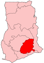
Map of Ghana showing Eastern region. |
||
| Dabsir | |||
| Tuŋ | Self-made, traced from public domain UN or CIA maps. | ||
| Creator | |||
| Suor tisib (Alɛn nɔ faali tʋm) |
Provide attribution, please. See below. | ||
| Georeferencing | If inappropriate please set warp_status = skip to hide. | ||
| Other versions |
See Image:Ghana regions named.png for the numbered map of the regions.
|

I, the copyright holder of this work, hereby publish it under the following licenses:
This file is licensed under the Creative Commons Attribution-Share Alike 2.5 Generic, 2.0 Generic and 1.0 Generic license.
- Fʋ mɔr suor
- anɔki pʋdig – Maalimɛ li taaba ka zaŋi pʋdig ka tʋʋma la yʋ'ʋn tɔlis
- Maligim gɛndig – zaŋim tʋʋma tʋm
- Din nar ye fʋ dɔlis suosieba nwa:
- pʋ'ʋsim – Di nar ye fʋ faas bɛɛ pa'al ye fʋ nif tigya ka mɛ pa'al fʋn paam laasin la si'el nɛ ti'as banɛ ka fʋ ti'as la. Fʋ na tun'e dɔlis suoya kɔn'ɔb-kɔn'ɔbi maal ala, amaa da niŋ ka li nwɛnɛ onɛ sʋ'oe laasin la tisif suorɛ.
- Pʋdigimi ka li zɛm taaba – Fʋ ya'a maligim sɔb nɛ bɛɛ ti'asi li nɛ, bɛɛ fʋ sɔbnɛ niŋ sɔb kʋdir la ni, li sʋ'ʋm ye fʋ pʋdig fʋn paas si'el la ka li dɔl nɛ same or compatible license di nannanŋin.

|
Suor bɛ ka fʋ nɔk sɔb nwa ka li nwɛnɛ fʋ dinɛ ka fʋ tu'e tɔdi li ka/bɛɛ ti'asi li ka li dɔlis zi'ela dinɛ GNU zaalim laasin gbana ni la, Version 1.2 bɛɛ gbauŋ paal ka ba yis din nya'aŋ na published by the Free Software Foundation; ka li pʋ mɔr ti'asa zin'isieba bɛɛ Tuon-Gbauŋ Sɔb nɛ Nya'aŋ-Gbauŋ Sɔpɔ. Laasin la tiraan paas ya'ar kanɛ zugu an ye GNU Free Documentation License. |
| Faal nwa kasɛta gbauŋ zi'enɛ Creative Commons Attribution-Share Alike 3.0 Unported kasɛta gbauŋ. | ||
| ||
| This licensing tag was added to this file as part of the GFDL licensing update. |
Fʋ tun'e gaŋ laasin kanɛ ka fʋ bɔɔd
Faal labaar
Dinsim dabsir/saŋa la ka gɔs labaar la yi saŋakan ka la na.
| Dabsir/Saŋa | Nu'u-ɛɛng | Titɔndis | Onɛ mɔri tʋm | Lɛbisʋg | |
|---|---|---|---|---|---|
| nannanna nwa | 09:19, 27 Sigir/Nwadisayɔpɔi 2005 | | 150 × 211 (4 KB) | Golbez | Map of Ghana showing Eastern region. Source: Made by User:Golbez. {{cc-by-sa-2.0}} Category:Maps of Ghana\ |
Faal tʋʋma
The following 8 pages use this file:
Dunia wʋsa faal tʋʋma
Wikis bama tʋmnɛ nɛ faal kaŋa:
- Zaŋim tʋm de.wikipedia.org
- Zaŋim tʋm dga.wikipedia.org
- Zaŋim tʋm en.wikipedia.org
- Akwatia (Ghana parliament constituency)
- Akim Swedru (Ghana parliament constituency)
- Atiwa (Ghana parliament constituency)
- Upper Manya (Ghana parliament constituency)
- Akropong (Ghana parliament constituency)
- Okere (Ghana parliament constituency)
- Aburi-Nsawam (Ghana parliament constituency)
- Ofoase-Ayirebi (Ghana parliament constituency)
- Asuogyaman (Ghana parliament constituency)
- Akim Oda (Ghana parliament constituency)
- Abirem (Ghana parliament constituency)
- Akim Abuakwa North (Ghana parliament constituency)
- Akim Abuakwa South (Ghana parliament constituency)
- Fanteakwa (Ghana parliament constituency)
- Kade (Ghana parliament constituency)
- Abetifi (Ghana parliament constituency)
- Afram Plains North (Ghana parliament constituency)
- Afram Plains South (Ghana parliament constituency)
- Mpraeso (Ghana parliament constituency)
- Nkawkaw (Ghana parliament constituency)
- Lower Manya (Ghana parliament constituency)
- New Juaben North (Ghana parliament constituency)
- New Juaben South
- Ayensuano (Ghana parliament constituency)
- Suhum (Ghana parliament constituency)
- Lower West Akim (Ghana parliament constituency)
- Upper West Akim
- Yilo Krobo (Ghana parliament constituency)
- Akwapim South (Ghana parliament constituency)
- Nsawam Adoagyiri (Ghana parliament constituency)
- Fanteakwa North (Ghana parliament constituency)
- Fanteakwa South (Ghana parliament constituency)
- Akuapem North (Ghana parliament constituency)
- Asene Akroso-Manso (Ghana parliament constituency)
- User:GerardM/Constituency of the Parliament of the Republic of Ghana
- Zaŋim tʋm gpe.wikipedia.org
- Abirem (Ghana parliament constituency)
- Akim Abuakwa North (Ghana parliament constituency)
- Akim Abuakwa South (Ghana parliament constituency)
- Akim Swedru (Ghana parliament constituency)
- Akwapim South (Ghana parliament constituency)
- Akwatia (Ghana parliament constituency)
- Asene Akroso-Manso (Ghana parliament constituency)
- Asuogyaman (Ghana parliament constituency)
- Ayensuano (Ghana parliament constituency)
- Fanteakwa North (Ghana parliament constituency)
Gɔsim more global usage faal kaŋa nwa ni.